Mitigation Bank
Lummi Nation Wetland and Habitat Mitigation Bank
About
The Lummi Nation Wetland and Habitat Mitigation Bank is the first tribally-owned and operated commercial wetland mitigation bank in the United States. It will be implemented in several phases; the first phase, Phase 1A (842 acres), became operational on October 18, 2012.
Purpose
The Wetland and Habitat Mitigation Bank will generate credits to compensate for unavoidable adverse impacts to the aquatic environment that occur as a result of permitted projects within the service area of the bank. Compensatory mitigation credits will be available for proposed projects within the mitigation bank service area after all practicable steps have been taken to avoid and minimize adverse impacts on the aquatic environment. The mitigation credits will be used to satisfy permit conditions or other regulatory requirements. The prospectus for the Lummi Nation Wetland and Habitat Mitigation Bank was available for public comment during December 2008 and January 2009.
Credits
Mitigation credits will be available for projects within the service area for the mitigation bank. The service area for the mitigation bank is generally the portions of Water Resources Inventory Area 1 (WRIA 1) downstream from the confluence of the North Fork, Middle Fork, and South Fork Nooksack River excluding the Lake Whatcom watershed.
Utilization of the Lummi Nation Wetland and Habitat Mitigation Bank to mitigate for unavoidable impacts to aquatic resources is subject to the approval of the regulatory agencies with jurisdiction over the impacting project and the Lummi Nation.Please see the IRT Mitigation Bank Use Plan Guidance document for requirements of regulatory agencies.
To request approval by the Lummi Nation, please complete the Online Mitigation Bank Credit Application Form.
Sites
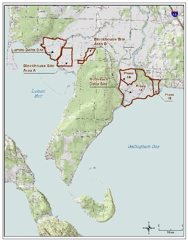
The Lummi Nation Wetland and Habitat Mitigation Bank is comprised of three separate sites: the Nooksack Delta Site, the Blockhouse Site, and the Lummi Delta Site.The total area of the mitigation bank is approximately 1,945 acres. The Bank will be developed in four phases. The Nooksack Delta Site contains 1,179 acres at the mouth of the Nooksack River and will be developed in two phases: Phase 1A and Phase 1B. The Blockhouse Site contains approximately 354 acres and will be implemented under Phase 2. The Lummi Delta Site contains approximately 412 acres and will be developed under Phase 3.
Service Area:
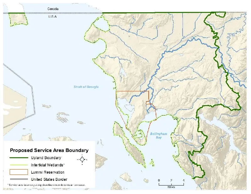
The Bank can be used to provide off-site compensatory mitigation for impacts to the Waters of the United States, Lummi Nation Waters, and Waters of the State of Washington, including wetlands, within a portion of Water Resources Inventory Area 1 ('WRIA 1'), which is described as the Nooksack River watershed and certain adjacent coastal stream systems.As shown in the Service Area Map, the service area of the Bank contains the following WRIA 1 drainages:South Fork Anderson, North Fork Anderson, Lower Anderson, Scott, Kamm, Fishtrap (U.S. portion), Bertrand (U.S. portion), Schneider, Fourmile, Tenmile, Deer, Fazon, Silver, Wiser Lake/Cougar Creek, North Fork Dakota, South Fork Dakota, Haynie, Lower Dakota, Blaine, California, Semiahmoo, Point Roberts, Fingalson, Lake Terrell, Cherry Point, Sandy Point Jordan, Schell, Lummi River, Lummi River Delta, Lummi Peninsula West, Lummi Peninsula East, Portage Island, Lummi Island, Eliza Island, Nooksack River Channel, Nooksack River Delta, Fort Bellingham, Spring, Baker, McCormick, Upper Squalicum, Toad, Lower Squalicum, Whatcom, South Bellingham, Padden, Chuckanut, Fragrance Lake, Larrabee, and Oyster Creek.
In addition to all freshwater waters of the U.S./Lummi Nation, the service area includes tidally influenced waters down to the elevation of Mean Lower Low Water (MLLW) along the edge of WRIA 1 from the Canadian border south to the southern boundary of the Oyster Creek drainage.The WRIA 1 sub-basins at the headwaters of streams in the Cascade Mountains and areas that cross the international boundary and/or discharge to the Fraser River system are not included in the Lummi Nation WHMB service area.
The Bank may be used to compensate for an impact that occurs within the Service Area if specifically approved by the regulatory agency(ies) that have jurisdiction over that impact, pursuant to the procedures and criteria prescribed in the Mitigation Banking Instrument.In exceptional situations, the Bank may be used to compensate for an impact that occurs outside of the Service Area if specifically approved by the regulatory agency(ies) having jurisdiction over that impact and by the Corps following consultation with the IRT.
Notice: This website uses javascript. If you are using a script blocking functionality in your browser you will be unable to use many of the tools on this site. Please whitelist LummiNaturalResources.org if you wish to avail yourself of the full functionality of this site. For search and mapping-related functionality, you may also need to whitelist google.com